| summary of proposal
|
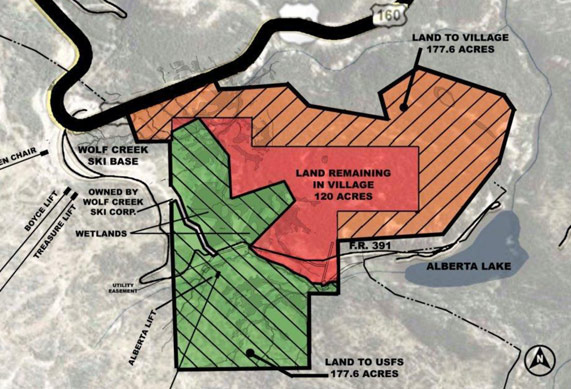
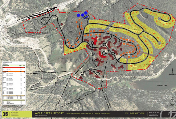
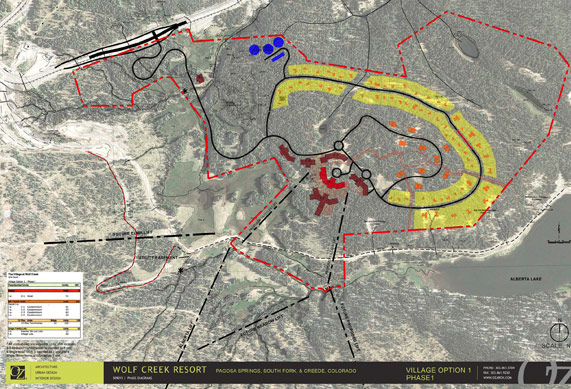
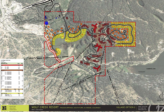
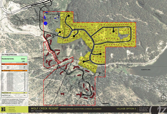
 Over one year ago, our new development team began looking at an alternative way to approach the layout of the currently approved plat of the Village at Wolf Creek. We did so in response to input we received from the surrounding communities, the US Forest Service and the ski resort operator. We met with Davey Pitcher, CEO of Wolf Creek Ski Corporation to gain his insight into a more compatible and less impactful plan for the Village. After much discussion, we developed a proposal that involves trading land we presently own (which includes wetlands and skiable terrain) in exchange for U.S. Forest Service land that is outside of the majority of wetlands and the skiable terrain at the base of the ski area. We also responded to suggestions from Mr. Pitcher to reduce the size of the Village and to build the Village in phases to be compatible with future skier capacity of the mountain. There are two processes (administrative and legislative) we could follow in order to gain approval for a federal land exchange. While we initially pursued both processes, we are presently only pursuing an administrative land exchange. This is largely due to the public commitments obtained by Congressman Salazar at a meeting in Alamosa in the Spring of 2010, where all of the represented groups (including groups that have been traditionally opposed to the Village) agreed to abide by the Forest Service’s conclusions and findings after a thorough, transparent public review process. In recognition of these public commitments, we are actively proceeding with the administrative process. In June, 2010, we submitted our initial land exchange proposal to the Forest Service that proposed exchanging 205 acres we own for 205 acres of land from the Forest Service. In July, 2010, we amended our original land exchange proposal to propose exchanging 177 acres of our land for 177 acres of land from the Forest Service. This change was due to a realignment of the ski lifts serving the Village after we learned that the ski area might not install one of the possible future ski lifts (the Tranquility Lift) that was to be accessible from the Village. With our amended land exchange proposal we have included a development plan labeled Option 1. Option 1 reflects a central pedestrian village with a full build-out of 1,711 residential units, comprised of hotels, condominiums, townhomes and single family homes. The proposed first phase of Option 1 contains 497 residential units that include one hotel containing 71 rooms.. Included in our proposal to the Forest Service, we have requested that the Forest Service grant us road access to our currently owned property under the Alaska National Interest Lands Conservation Act (ANILCA) if the land exchange were not to occur. ANILCA is a federal statute that guarantees private landowners adequate access across federal lands for their reasonable use of their intended purpose for their land. In the event we or the Forest Service decide not to proceed with the land exchange, we have asked the Forest Service to also consider our request for road access so that we may develop the Village on the land we currently own. We have submitted two separate development plans to the Forest Service for ANILCA analysis. (See Option 2 and Option 3). Option 2 is a new development plan on our land that attempts to incorporate the central pedestrian village reflected in Option 1. Option 3 is the plan that presently has preliminary approval in Mineral County. In our public meetings held over the past year to discuss possible Village development options, the overwhelming majority of participants responded positively toward a proposed land exchange when compared to the option that has preliminary approval in Mineral County (Option 3). We share the opinion that the land exchange presents the best alternative of the three; however, we are prepared to proceed with Option 2 or possibly with Option 3 in the event the land exchange proposal is rejected by the Forest Service. If, after reviewing these materials, you favor the land exchange proposal (Option 1) over the two ANILCA alternatives (Options 2 or 3), please communicate your support for the land exchange to the Regional Supervisor for the Rio Grande National Forest and to your other locally elected officials. Below are the maps and plans that depict the land exchange boundary and all three options. ”Map 1” reflects the land exchange boundaries. The plan labeled “Option 1” reflects the land exchange proposed development at full build-out. The plan labeled “Option 1 Phase 1” reflects the first phase of the land exchange development. The plan labeled “Option 2” reflects the newly designed development plan on the land we currently own, and the plan labeled “Option 3” shows the preliminarily approved plan in Mineral County as modified by certain agreements reached with the ski area. If you have questions after reviewing these materials, please contact Clint Jones at clint@haljonesdev.com or by telephone at (512) 402-1400. |
| Land exchange boundries
back to top |
|
| option 1
back to top |
|
| Option 1, Phase 1 site map back to top |
 |
| Option 2 site map back to top |
 |
| Option 3 site map back to top |
 |